deutsch englisch spanisch französisch italienisch
Ausschnitt aus der Tabula Peutingeriana - Rom

Tabula Peutingeriana – Einzelanzeige

Toponym TP (aufgelöst):

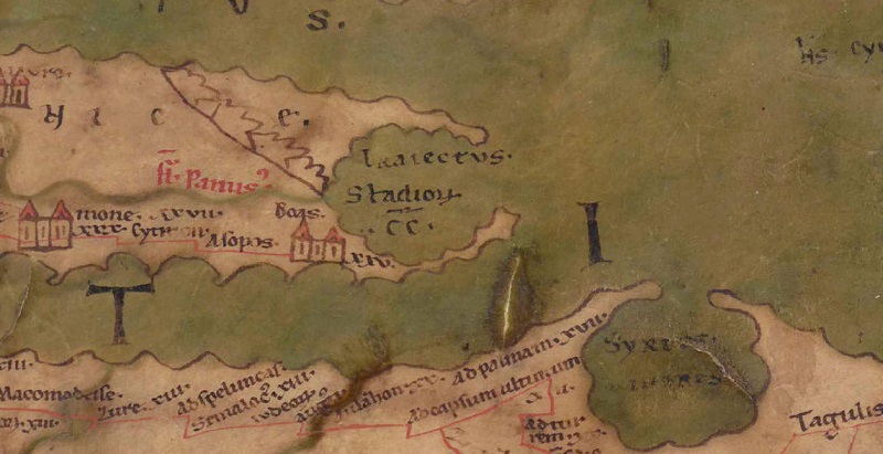
Traiectvs Stadiorum CC (Traiectus Stadiorum CC)

Name (modern):


Bild:
Zum Bildausschnitt auf der gesamten TP
Toponym vorher Boas     
Toponym nachher Insula Cytera     
Alternatives Bild ---
Bild (Barrington 2000)
Bild (Scheyb 1753) ---
Bild (Welser 1598) ---
Bild (MSI 2025) ---
Großraum:

Balkanraum südlich

Toponym Typus:

Itinerareintrag/via publica

Planquadrat:

7B1 / 7C1

Farbe des Toponyms:

schwarz

Vignette Typus :

---

Itinerar (ed. Cuntz):


Alternativer Name (Lexika):


RE:


Barrington Atlas:


TIR / TIB /sonstiges:


Miller:

Traiectvs Stadiorum c¯c¯

Levi:


Ravennat:


Ptolemaios (ed. Stückelberger / Grasshoff):


Plinius:


Strabo:


Autor (Hellenismus / Späte Republik):


Datierung des Toponyms auf der TP:

---

Begründung zur Datierung:


Kommentar zum Toponym:

Kommentar (Talbert):
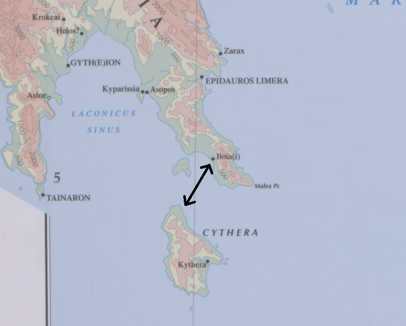
"CC" has a macron. For the mapmaker to note a sea-crossing is most unusual. So, too, is the specification of the unit of distance; see Chapter 3 sect. 4 (b). 200 stades = 25 Roman miles at the standard 8 stades to the mile. This is in fact approximately the distance from Boia(i) to the settlement Kythera (BAtlas 58 E4 and inset); Miller may therefore be right in urging that the crossing meant by the mapmaker is from Boas to Ins. Cytera (#71). The only certain point, however, is that our copy of the map does not clarify adequately which crossing is meant.

Miller, Itineraria, Sp. 569:
In dem hier gezeichneten buchtartigen Abschluß des Peloponneses steht (schwarz - im Meere):
Traiectvs Stadiorum c¯c¯ = 25 mp - nämlich auf die Insel Cythera (Cerigo). Der Landungsplatz auf Cythera war bei Palaiopoli (südlich von Hagios Nikolaos, dem heutigen Landungsplatz). Nach Pl 4, 56 ist Cythera von Maleae nur 5 mp entfernt (offenbar unrichtig); die nächste Entfernung beträgt 25 km, nach Kapsali (ganz im Süden der Insel) 38 km, von Boas nach Palaeopoli 35 km, es stimmt demnach genau die Entfernung von 25 mp für die Überfahrt von Boas nach Palaeopoli. - - Ganz falsch deutet Schweder (in Fleckeisens N. Jahrb. 147, B. 1983 p. 493) Traiectus Stadiorum CC als den geradlinigen Abstand der beiden den Meerbusen begrenzen Vorgebirge; ähnlich Kubitschek (Eine römische Straßenkarte, p. 55). Eine solche rein theoretische Frage liegt dem Zweck der Itinerarien gänzlich ferne.

Literatur:

Miller, Itineraria, Sp. 569.

RE: -

   [Standard-Literatur-Liste im PDF-Format]

Letzte Bearbeitung:

06.02.2024 17:22

Druckversion erstellen


Cite this page:
https://tp-online.ku.de/trefferanzeige.php?id=2233 [zuletzt aufgerufen am 03.10.2026]

Impressum Datenschutzerklärung