deutsch englisch spanisch französisch italienisch
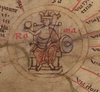
Ausschnitt aus der Tabula Peutingeriana - Rom

Tabula Peutingeriana – Display individuale

Toponimo TP (sciolto):

Gagonda

Nome (moderno):

bei Almus?

Foglio:
Al dettaglio dell'immagine
Toponimo davanti XVI     Comana pontica (Comana Pontica)     
Toponimo dopo V     Magabula     
Foglio alternativo: ---
Foglio (Barrington 2000)
Foglio (Scheyb 1753)
Foglio (Welser 1598) ---
Foglio (MSI 2025) ---
Pleiades: https://pleiades.stoa.org/places/857129
Area:

Asia Minore

Tipo di toponimo:

nome di luogo senza simbolo

Quadrato:

9B3

Colore di toponimo:

nero

Tipo di vignetta:

---

Nome (Itinerario):


Nome alternativo (dizionari):


Nome (RE):


Nome (Barrington):

Gagonda (87 B4)

Nome (TIR / TIB /altro):


Nome (Miller):

Gagonda

Nome (Levi):


Nome (Ravennat):


Nome (Ptolemaios):


Plinius:


Strabo:


Datazione del toponimo sulla TP:

---

Giustificazione della datazione:


Commento al toponimo:

Gagonda ist sonst nicht in der Literatur belegt.

Möglicherweise identisch mit dem hethit. Ort Kakatuwa (Literatur bei Carnevale 2020, 486f).

Casus: wahrscheinlich neutr. plur. Nominativ oder Richtungsakkusativ, wie aus der vorangehende Legende “Acomana pontica Gagonda” zu schließen ist (allerdings sind derartige Legenden, offenbar übernommen aus einem Itinerar, in der TP nicht immer konsequent an die verwendete Namensform an der Ortschicane angeglichen).

Station an der antiken Straße von Comana Pontica (9B2) nach Nikopolis (9A/B5 Nicopoli),
heute bei Almus lokalisiert (z. B. Olshausen/Biller 1985, 131; Bryer/Winfield 1985, 24; BAtlas 87 B4; laut ItMiller 675 zwischen Georek/Gevrek und Kavakly/Kevaklik;), wo eine Brücke übr den 3 km entfernten Iris führte. Die Stelle, früher Kadiköprüsü, ist heute von einem Staussee überflutet (s. Olshausen/Biller 1985, 131).

In Almus wurden viele antike Trümmer gesichtet; Rest einer griech. Inschrift als Spolie verbaut in einem Kloster, ½ Stunde vom Dorf (s. de Jerphanion 1908, 445).

Meilenangabe nach Magabula: V (5).


Miller, Itineraria, Sp. 675:
Gagonda; j. am obersten Iris, zwischen Georek und Kevak; nach R Kp Almush.

Letteratura:

Bryer, W./Winfield, D.: The Byzantine Monuments and Topography of the Pontos 1, Washington 1985, 23f.

Carnevale, Antonio: La frontiera nord-orientale dell’Impero Ittita, Diss. Rom 2018, 38; 54; 486f.

de Jerphanion, G.: Inscriptions d´Asie Mineure (Pont, Cappadoce, Cilicie), Mélanges de la Faculté Orientale de Beyrouth 3 (1908), 437-478, 445f.

Miller, Itineraria, Sp. 675.

Olshausen, E./Biller, J.: Historisch-geographische Aspekte der Geschichte des Pontischen und Armenischen Reiches. Teil I. Untersuchungen zur historischen Geographie von Pontos unter den Mithridatiden (= TAVO B 29/1), Wiesbaden 1984, 131.


RE: -

   [Standard-Literatur-Liste im PDF-Format]

Ultima modifica:

18.08.2025 17:05


Cite this page:
https://tp-online.ku.de/trefferanzeige_it.php?id=1381 [zuletzt aufgerufen am 11.11.2026]

Impressum Datenschutzerklärung