
Tabula Peutingeriana – Single display of hits
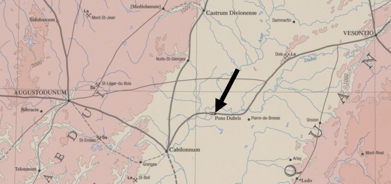
| Toponym TP (renewed): | Ponte Dubris |
| Name (modern): | settlement and bridge at Pontoux |
| Image: | 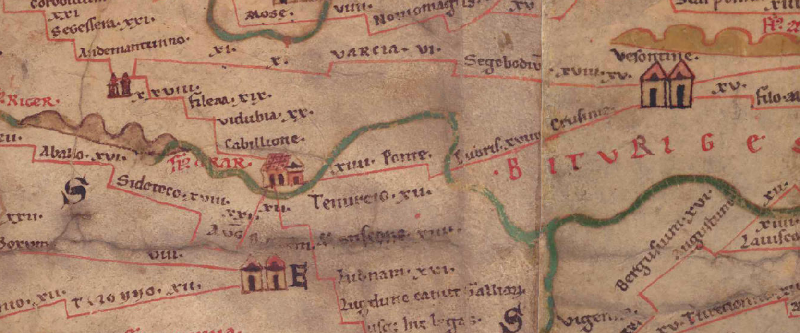 To the image detail |
| Toponym before | XIIII Cabillione |
| Toponym following | XVIII Crusinie |
| Alternative Image | --- |
| Image (Barrington 2000) |
 |
| Image (Scheyb 1753) | --- |
| Image (Welser 1598) | --- |
| Image (MSI 2025) | --- |
| Pleiades: | https://pleiades.stoa.org/places/177607 |
| Area: | Gaul/Germania |
| Toponym Type: | Toponym, no Symbol |
| Grid square: | 1B5 |
| Toponym Color: | black |
| Vignette Type : | --- |
| Itinerary: |
|
| Alternative Name (Lexica): | P. Dub(r)is (DNP) |
| Name A (RE): | Pons [12] Dub(r)i - https://elexikon.ch/RE/XXI,2_2465.png |
| Name B (Barrington Atlas): | Pons Dubris (18 C3) |
| Name C (TIR/TIB/others): |
|
| Name D (Miller): | Ponte. Dubris |
| Name E (Levi): |
|
| Name F (Ravennate): |
|
| Name G (Ptolemy): |
|
| Plinius: |
|
| Strabo: |
|
| Dating from Toponym on TP: | --- |
| Argument for Dating: |
|
| Commentary on the Toponym: |
Kommentar (Talbert): |
| References: |
Desjardins, Table, p. 34, col. 1, no. 1. |
| Last Update: | 07.01.2026 19:32 |
Cite this page:
https://tp-online.ku.de/trefferanzeige_en.php?id=3388 [last accessed on June 25, 2026]