


Tabula Peutingeriana – Display individuale
| Toponimo TP (sciolto): | Fossa Facta Per Seruos Scutarum (Fossa Facta Per Servos Scutarum) |
| Nome (moderno): |
|
| Foglio: | 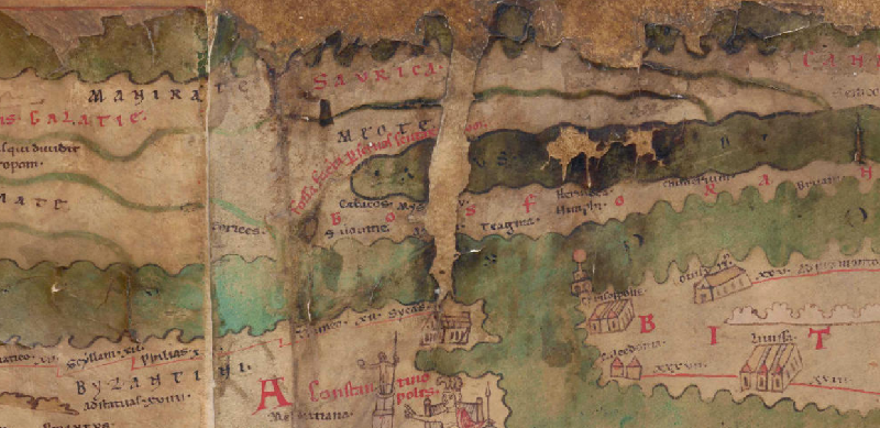 Al dettaglio dell'immagine |
| Toponimo davanti | |
| Toponimo dopo | |
| Foglio alternativo: | --- |
| Foglio (Barrington 2000) |
 |
| Foglio (Scheyb 1753) | --- |
| Foglio (Welser 1598) | --- |
| Foglio (MSI 2025) | --- |
| Area: | Scizia |
| Tipo di toponimo: | informazioni corografiche |
| Quadrato: | 8A1 |
| Colore di toponimo: | rosso |
| Tipo di vignetta: | --- |
| Nome (Itinerario): |
|
| Nome alternativo (dizionari): |
|
| Nome (RE): | Taphrai |
| Nome (Barrington): | Taphros (23 G2) |
| Nome (TIR / TIB /altro): |
|
| Nome (Miller): | Fossa facta per servos Scutarum (618. 958) |
| Nome (Levi): |
|
| Nome (Ravennat): |
|
| Nome (Ptolemaios): | Τάφρος (3,6,5) |
| Plinius: |
|
| Strabo: |
|
| Datazione del toponimo sulla TP: | --- |
| Giustificazione della datazione: |
|
| Commento al toponimo: |
Millers Rekonstruktion der Beischrift (ItMiller 618. 958) dürfte nicht richtig sein, da die zerstörte Stelle Platz für 2-3 weitere Buchstaben bietet: Anstatt Scutarum ist eher Scutaeorum anzusetzen. Für die Präposition per wird die gängige Abbreviatur mit Querstrich durch den Schaft des p benutzt. Miller (Weltkarte 111; Itinerarium 618. 958) identifiziert diese Örtlichkeit mit der Landenge von Perekop, die von einem Graben durchzogen und auf der Südseite von einem Wall begrenzt ist. Der Graben wird bei Strabo und Plinius als künstlicher Abfluss für das Wasser aus dem Byce- oder Bucessee in das Meer (Plin. nat. 4, 84: lacus Buces, fossa emissus in mare) verstanden. Strabo berichtet auch von einer anderen, ähnlich konstruierten Befestigungsanlage auf dieser Landenge, die von den Kimmeriern angelegt worden sei (Strab. 11, 2, 6 [494]). Von Miller nicht in Erwägung gezogen, aber z.B. von Podossinov gesehen wurde die Verbindung dieser Beischrift mit Herodots Skythen-Logos: Die geblendeten Sklaven der Skythen, die die Stuten melken und die Milch rühren mussten, zeugten mit den skythischen Frauen Kinder, als deren Männer im Krieg waren. Die aus diesen Verbindungen hervorgegangenen Söhne stellten sich den Heimkehrern zur Schlacht entgegen (Hdt. 1, 3; 4, 3, 1; vgl. 28, 1) und hoben einen Graben (τάφρος) aus, der von den taurischen Bergen bis zur Maiotis-See reichte (Hdt. 4, 3, 2). - Vgl. lac· salinar(um)· hic sal p(er)se c(on)ficitur· (Siwasch). |
| Letteratura: | Wilhelm Tomaschek, in: RE III / 1, 1897, 1104f. s.v. Byke; Matija P. Katančić, Orbis antiquus ex tabula itineraria quae Theodosii Imp. et Peutingeri audit ad systema geographiae redactus et commentario illustratus, Pars I, Buda 1824, 212-214; Miller, Weltkarte 111; Ders., Itineraria, Sp. 618. 958; Albert Herrmann, in: RE IV A / 2, 1937, 2258f. s.v. Taphrai; Alexander V. Podossinov, Das Schwarze Meer in der geokartographischen Tradition der Antike und des frühen Mittelalters. II. Die Halbinsel Krim, das Asowsche Meer und die Straße von Kertsch, in: East & West 3 / 2, 2004, 338-353, hier 340. [Standard-Literatur-Liste im PDF-Format] |
| Ultima modifica: | 20.03.2023 21:55 |
Cite this page:
https://tp-online.ku.de/trefferanzeige_it.php?id=2297 [zuletzt aufgerufen am 11.11.2026]