deutsch englisch spanisch französisch italienisch
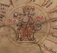
Ausschnitt aus der Tabula Peutingeriana - Rom

Tabula Peutingeriana – Display individuale

Toponimo TP (sciolto):

Palalce

Nome (moderno):

Baraklı

Foglio:
Al dettaglio dell'immagine
Toponimo davanti XV     Amasia     
Toponimo dopo XII     Coloe     
Foglio alternativo: ---
Foglio (Barrington 2000)
Foglio (Scheyb 1753)
Foglio (Welser 1598) ---
Foglio (MSI 2025) ---
Pleiades: https://pleiades.stoa.org/places/857262
Area:

Asia Minore

Tipo di toponimo:

nome di luogo senza simbolo

Quadrato:

9A1

Colore di toponimo:

nero

Tipo di vignetta:

---

Nome (Itinerario):


Nome alternativo (dizionari):


Nome (RE):

Palalce

Nome (Barrington):

Palalce (87 B4)

Nome (TIR / TIB /altro):


Nome (Miller):

Palalce

Nome (Levi):


Nome (Ravennat):

Pallagres (p. 28,32)

Nome (Ptolemaios):

? s. Kommentar

Plinius:


Strabo:


Datazione del toponimo sulla TP:

tarda antichità (da Diocleziano & IV secolo)

Giustificazione della datazione:

Unsicher. Erstmals klar präsent in der gemeinsamen spätantiken Vorlage von TP und Ravennas. Besiedelt allerdings schon spätestens seit hellenist. Zeit, wie archäolog. Reste erkennen lassen. Identifizierung mit Piala bei Ptol. fraglich.

Commento al toponimo:

Namensform nur hier belegt.

Alternative Namensform:
Pallagres Rav 2,16 p. 28,32 Mironi Pephagonie. item civitas Pallagres, Amasia, Garse.
Diese Toponymform scheint im modernen Namen Baraklı nachzuklingen (s. Ruge, RE 2499).

Vielleicht lautete die Schreibung in der gemeinsamen Vorlage von TP und Rav “Palacres”?

(Fraglich ist eine Verschreibung aus Πίαλα Ptol. 5,6,9, bzw. aus Pialasus, vermutet von Cramer 1832, offenbar geteilt von ed. Stückelberger S. 51, der Piala mit Baraklı identifiziert, anders als BAtlas S. 1240).

Lokalisierung vermutlich bei Baraklı (so z. B. schon ItMiller 669 und Ruge, RE 2499), wo ein Meilenstein der Straße von Amaseia über Eupatoria nach Neokaisareia aus der 1. Jh. des 4. Jh.s n. Chr. gefunden wurde, G. de Jerphanion, Mélanges de la Faculté Orientale de Beyrouth 3 (1906), 441 Nr. 1 (s. Olshausen/Biller 1984, 153), was zu den Distanzangaben auf der TP von Amasya aus passen würde (s. Ruge, RE 2499).
2 km von Baraklı entfernt befindet sich ein kleiner Siedlungshügel, Yukarı Baraklı 2 km, von 50 x 30 m Ausdehnung, wo hellenist. Keramikreste gefunden wurden (s. Dönmez 1998, 520f).

Meilenangabe nach Coloe: XII (12).


Kommentar (Talbert):
-> Stretch to Coloe
The start of this stretch is not marked.

Miller, Itineraria, Sp. 669:
15.Palalce, Pallagres (Ra); j. Barakly am Barakly Dagh.

Letteratura:

Cramer, John Anthony: A Geographical and Historical Description of Asia Minor, vol. I, Oxford 1832, 319.

Dönmez, Şevket: Sinop-Samsun-Amasya İlleri Yüzey Araştırması, Araştırma Sonuçları Toplantıları 16,2 (1998), 513-536, hier: 520f.

Erciyas, Deniz Burcu Arıkan: Wealth, aristocracy and royal propaganda under the hellenistic kingdom of the Mithradatids, Leyden 2006, 56.

Miller, Itineraria, Sp. 669.

Olshausen, E./Biller, J.: Historisch-geographische Aspekte der Geschichte des Pontischen und Armenischen Reiches. Teil I. Untersuchungen zur historischen Geographie von Pontos unter den Mithridatiden (= TAVO B 29/1), Wiesbaden 1984, 153f.

Ruge, W.: Palalce, RE XVIII.2 (1942), Sp. 2499.

Wilson, D. R.: The Historical Geography of Bithynia, Paphlagonia and Pontus in the
Greek and Roman Periods: a new survey with particular reference to surface remains
still visible, Diss. Oxford 1966, 389.

   [Standard-Literatur-Liste im PDF-Format]

Ultima modifica:

17.08.2025 20:48


Cite this page:
https://tp-online.ku.de/trefferanzeige_it.php?id=1362 [zuletzt aufgerufen am 11.11.2026]

Impressum Datenschutzerklärung