deutsch englisch spanisch französisch italienisch
Ausschnitt aus der Tabula Peutingeriana - Rom

Tabula Peutingeriana – Pantalla individual

Topónimo (simplificado):

Tarsatica

Nombre (moderno):

Trsat

Imagen:
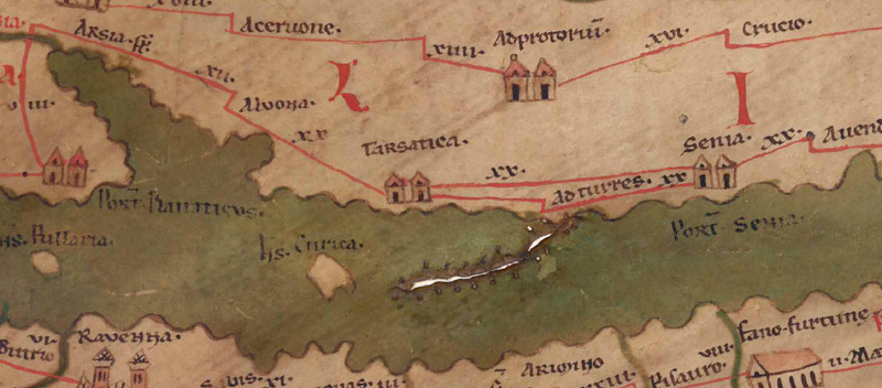
Al detalle de la imagen
Topónimo antes XX     Alvona     
Topónimo después -     Ad Turres     XX     Senia     
Imagen alternativa ---
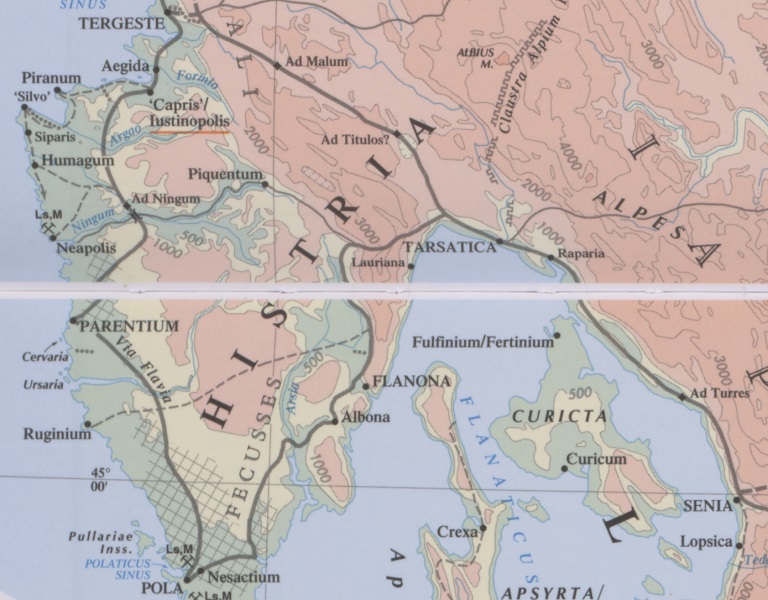
Imagen (Barrington 2000)
Imagen (Scheyb 1753) ---
Imagen (Welser 1598) ---
Imagen (MSI 2025) ---
Pleiades: https://pleiades.stoa.org/places/197541
Área:

Área de los Balcanes del norte

Tipo de topónimo:

Topónimo con símbolo

Cuadrícula:

4A1 / 4B1 / 4A2 / 4B2

Color del topónimo:

negro

Tipo de viñeta:

A Torre doble

Itinerario:

Tharsatico (273, 5)

Nombres alternativos (diccionarios):

Tarsatica (DNP)

Nombre A (RE):

Tarsatica

Nombre B (Barrington Atlas):

Tarsatica (20 B4)

Nombre C (TIR / TIB /otros):

Tarsatica ad flumen Oeneus (TIR L 33, 71f )

Nombre D (Miller):

Tarsatica

Nombre E (Levi):

Tarsatica (A,II,1)

Nombre F (Ravenate):

Tharsaticum (4,22 p. 59.12; 5,14 p. 95.23); a civitate Tharsatico (4,37 p. 76.5)

Nombre G (Ptolemaios):

Ταρσατικά (2,16,2)

Plinius:


Strabo:


Datación del topónimo en la TP:

Comienzos del imperio (incluida la dinastía flavia)

Fundamento para la datación:

Namensform belegt bei Plin nat. 3,140 und Ptol. 2,16,2. Stadtrechte wohl unter Hadrian , was die Vignette rechtfertigen würde. Größere Bedeutung allerdings in der Kaiserzeit (s. Kommentar).

Comentario al topónimo:

Gleiche Namensform:
Plin. nat. 3,140 Tarsatica /aufgezählt zwischen Flanonia und Senia)
Ptol. 2,16,2 Ταρσατικά

Alternative Namensformen:
Ältester Beleg für den Ort: Ps.-Skylax 21 Ἴδασσα (Idassa(a)ti[ka]; die beiden aufeinanderfolgenden Wörter Ἴδασσα Ὰττιενίτης korrigiert Gronovius zu Δαρσάτικα, Σενίτης, zustimmend Müller GGM ad loc.
Tharsatico ItAnt. 273,5; Rav 4,37 76,5 a civitate Tharsatico; Guido 5.
Tharsaticum Rav 4,22 59,12; Guido 116.

Inschriftlich belegt seit spätestens Ende 1. Jh. n. Chr.: CIL 3, 14579 (s. Fluss, RE 2419). – Ein oppidum war es lt. Plin. 3,140, wohl eine Ansiedlung römischer Bürger ohne munizipale Verfassung. Die Stadtrechte besaß es wohl erst seit Kaiser Hadrian (s. Fluss, RE 2419). Es gehörte zur tribus Sergia (duoviri, decuriones: CIL III, 3027-3029, s. Cabanes DNP). In der späten Kaiserzeit war Tarsatica ein wichtiger Stützpunkt in den Julischen Alpen (s. Bosio 1974, 86). Es war dicht besiedelt und erhielt eine Doppelmauer ab 4. Jh. n. Chr. (s. Matijašić R./M. Čaušević).

Keine Abstandsabgabe nach Ad Turres, Abstand nach Senia: xx Meilen (ca. 32 km). Dazu der Kommentar von Talbert:
The duplication of routes between Tarsatica and Senia is a puzzle. It is conceivable, as Miller conjectures, that one is intended as a land route, the other by sea. BAtlas 20 B4 makes duplication on the ground seem unlikely. Alternatively, perhaps at some stage a copyist placed the two distance figures and the name Adtvrres in such a way that a later copyist thought two routes had to be drawn rather than just one. Note that ItAnt 273, 5-7 lists Tharsatico XVII-Ad Turres XX-Senia XX.

Miller, Itinerariia, Sp. 463:
Tarsatica, it. (Pt, Pl, Annal. Lauriss. a. 799), Tharsaticum Ra-bis, die Praetoria Liburnia Tharsaticensis, Tharsatico (It), Tharsatica (Einhardi Ann. a. 799); j. Tersatto oder Tersetto bei Fiume mit Ruinen. Iss: CIL III 3026-3029.
10061. Was der doppelte Verbindungsstrich von Tars. bis Senia bedeuten soll, ist nicht klar (Seeweg und Landweg?). Jedenfalls sind beide Zahlen jedesmal notwendig.

Datierung (Barrington):
Tarsatica - Hellenistic, Roman, Late Antique (Mlakar 1962, 38-39; Šašel 1971, 53-57).

DNP:
Tarsatica

Dieser Ort ist auf folgenden Karten verzeichnet:

Straßen

Liburnische Küstenstadt an der Straße von Aquileia [1] nach Siscia (Plin. nat. 3,140; Tab. Peut. 5,1 f.; Itin. Anton. 273: Tharsatico), h. Trsat östl. von Rijeka. Oppidum, tribus Sergia (duoviri, decuriones: CIL III, 3027-3029).

Bibliografía:

Bosio, Luciano: L´Istria nella descrizione della Tabula Peutingeriana, Trieste 1974, 85f.

Cabanes, Pierre; Ü: E.N., “Tarsatica”, in: Der Neue Pauly, Herausgegeben von: Hubert Cancik,, Helmuth Schneider (Antike), Manfred Landfester (Rezeptions- und Wissenschaftsgeschichte). Consulted online on 17 February 2018
First published online: 2006.

Fluss, Max: Tarsatica, RE II 4,2 (1932), 2419.

Karković Takalić P./ Predoević Zadković P./Višnjić J.: Nova arheološka karta antičke i ranosrednjovje kovne Tarsatike – The new archaeological map of ancient and early medieval Tarsatica, Histria archaeologica 45 (2014), 113-136.

Matijašić R./M. Čaušević Bully: Tarsatica http://adriaticummare.org/adriatlas?idSite=94
Mlakar 1966, 38-39.

Miller, Itineraria, Sp. 463.

Šašel, Jaroslav: Claustra Alpium Iuliarum I, Katalogi in monografije 5, Ljubljana 1971.

Šašel, Jaroslav: Alpium Iuliarum Claustra, RE Suppl. 13 (1973), 11-14.


Višnjić, Josip/Bekiċ, Luka: The Late Roman Principia in Tarsatica, part of Claustra Alpium Iuliarum, in: Hodgson, N./Bidwell, Paul T./Schachtmann, Judith (Hgg.): Roman frontier studies 2009: proceedings of the XXI International Congress of Roman Frontier Studies (Limes Congress) held at Newcastle-upon-Tyne in August 2009, Oxford 2017, 488-494.

Vitelli Casella, Mattia: La Liburnia settentrionale in età romana: studi di geografia ed istituzioni, Diss. Bologna 2011, 60-73.
http://amsdottorato.unibo.it/4164/1/vitellicasella_mattia_tesi.pdf.

Cabanes, Pierre; Ü:E.N.
J. Šašel, s. v. Alpium Iuliarum Claustra, RE Suppl. 13, 11-14.

   [Standard-Literatur-Liste im PDF-Format]

Última elaboración:

31.12.2024 18:08


Cite this page:
https://tp-online.ku.de/trefferanzeige_es.php?id=674 [zuletzt aufgerufen am 19.04.2026]

Derechos Política de privacidad