
Tabula Peutingeriana – Single display of hits
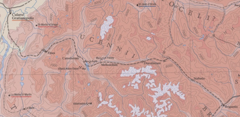
| Toponym TP (renewed): | Mellosecto |
| Name (modern): | Mont de Lans |
| Image: | 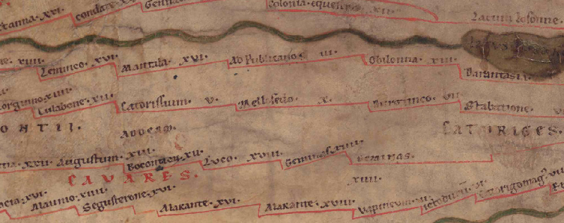 To the image detail |
| Toponym before | V Catorissium |
| Toponym following | X Durotinco |
| Alternative Image | --- |
| Image (Barrington 2000) |
 |
| Image (Scheyb 1753) | --- |
| Image (Welser 1598) | --- |
| Image (MSI 2025) | --- |
| Area: | Gaul/Germania |
| Toponym Type: | Toponym, no Symbol |
| Grid square: | 2B2 |
| Toponym Color: | black |
| Vignette Type : | --- |
| Itinerary: |
|
| Alternative Name (Lexica): |
|
| Name A (RE): | Mellosedum |
| Name B (Barrington Atlas): | Mellosedum (17 G3) |
| Name C (TIR/TIB/others): |
|
| Name D (Miller): | Mellosecto |
| Name E (Levi): |
|
| Name F (Ravennate): |
|
| Name G (Ptolemy): |
|
| Plinius: |
|
| Strabo: |
|
| Dating from Toponym on TP: | --- |
| Argument for Dating: |
|
| Commentary on the Toponym: |
Miller, Itineraria, Sp. 102: |
| References: |
Desjardins, Table, p. 57, col. 3, no. 5. |
| Last Update: | 08.01.2026 14:18 |
Cite this page:
https://tp-online.ku.de/trefferanzeige_en.php?id=3267 [last accessed on June 25, 2026]