deutsch englisch spanisch französisch italienisch
Part of Tabula Peutingeriana - Rome

Tabula Peutingeriana – Single display of hits

Toponym TP (renewed):

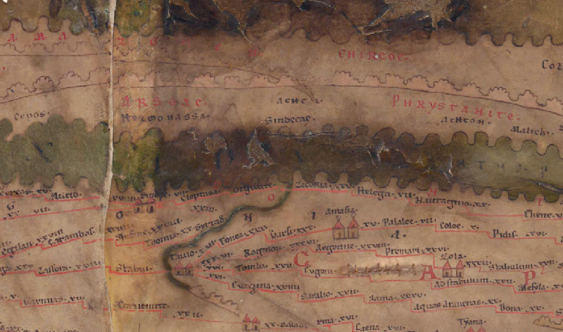
Achei

Name (modern):


Image:
To the image detail
Toponym before
Toponym following
Alternative Image ---
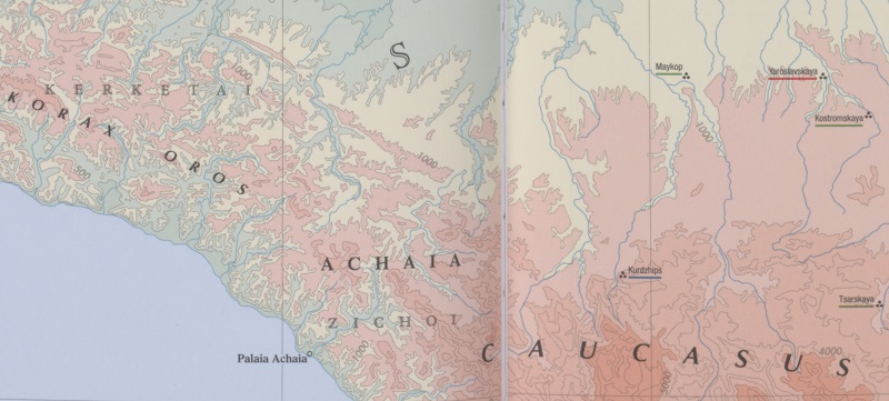
Image (Barrington 2000)
Image (Scheyb 1753) ---
Image (Welser 1598) ---
Image (MSI 2025) ---
Pleiades: https://pleiades.stoa.org/places/825220
Area:

Asia East of the Maiotis (Sea of Azov), North of Taurus

Toponym Type:

Ethnicon

Grid square:

9A1

Toponym Color:

black

Vignette Type :

---

Itinerary:


Alternative Name (Lexica):


Name A (RE):

Achaia [8] - https://elexikon.ch/RE/I,1_197.png

Name B (Barrington Atlas):

Achaia (84 E4) (region)

Name C (TIR/TIB/others):


Name D (Miller):


Name E (Levi):


Name F (Ravennate):


Name G (Ptolemy):


Plinius:


Strabo:


Dating from Toponym on TP:

---

Argument for Dating:


Commentary on the Toponym:

Kommentar (Talbert):
See note under Sorsdesertvs (7A5).

It is not apparent why the last two letters of the name should be set so far apart from one another.

Possibly it is the same people who are marked as "Acheon" in 9A2. If one of these names is perhaps to be understood as a people, and the other as their settlement or region, the map makes no discernible distinction.

Miller, Itineraria, Sp. 622:
Achei, als Volksstamm (Pt) am kimmerischen Bosporus; Achaei (Scyl, St, App, Mithr, Dion, Ml, Pl), neben den Sindi (cf. Am 22, 8, 25), 599 Stadien weit längs der Küste (St). Achaeer, nach dem Trojanischen Krieg verschlagen, fanden nach Dion. Nirgends Wohnplätze bis hoch im Gebirge mit ewigem Schnee; sie leben vom Raub. Ihre Stadt Acheon s.o.

Kommentar (RE):
Ἡ παλαιὰ Ἀχαΐα (Arr. peripl. 18, 4 mit dem Beisatz des Anonymos im cod. Lond. ὁ νῦν Τοψίδας ποταμός, bei Ptol. V 9, 8 Ἀχαία κώμη), Localität an der pontischen Ostküste im Lande der Achaioi (s. d. No. 2), östlich von der ἄκρα Τορετική (jetzt Idokopas), westlich vom κόλπος Κερκετικός; ganz in derselben Lage verzeichnen die ital. Portulane des 14. Jhdts. den Hafen Maura Zechia. [Tomaschek. ]

References:

A.V. Podossinov, Eastern Europe in Roman Cartographic Tradition (Moscow, 2002) [in Russian], 359;

Miller, Itineraria, Sp. 622;

Tomaschek, Wilhelm, Achaia 8, in: RE I.1 (1893), Sp. 198.

Tomaschek, Wilhelm, Achaioi 2, in: RE I.1 (1893), Sp. 204f.

   [Standard-Literatur-Liste im PDF-Format]

Last Update:

14.10.2025 12:13


Cite this page:
https://tp-online.ku.de/trefferanzeige_en.php?id=1982 [last accessed on September 20, 2026]

Edition Information Privacy Statement