deutsch englisch spanisch französisch italienisch
Ausschnitt aus der Tabula Peutingeriana - Rom

Tabula Peutingeriana – Einzelanzeige

Toponym TP (aufgelöst):

[Fl. Nasabath] (Miller)

Name (modern):

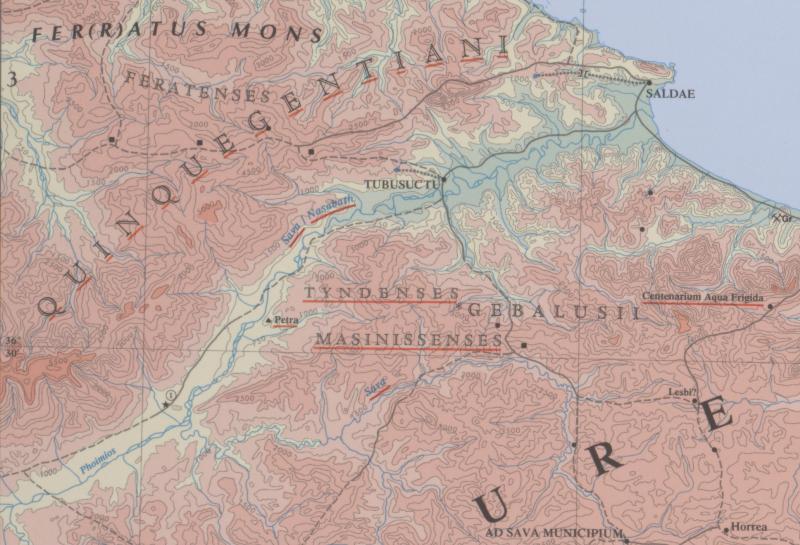
Oued bou Sellam / Oued Summam (Barrington) / Sahel (Miller)

Bild:
Zum Bildausschnitt auf der gesamten TP
Toponym vorher
Toponym nachher
Alternatives Bild ---
Bild (Barrington 2000)
Bild (Scheyb 1753) ---
Bild (Welser 1598) ---
Bild (MSI 2025) ---
Pleiades: https://pleiades.stoa.org/places/305148
Großraum:

Mauretanien

Toponym Typus:

Fluss

Planquadrat:

1C2 / 1C3 / 1C4

Farbe des Toponyms:

ohne Farbe

Vignette Typus :

---

Itinerar (ed. Cuntz):


Alternativer Name (Lexika):


RE:

Nasabath

Barrington Atlas:

Sava fl./Nasabath fl. (31 B3)

TIR / TIB /sonstiges:


Miller:

[Fl. Nasabath]

Levi:


Ravennat:


Ptolemaios (ed. Stückelberger / Grasshoff):

Nασαβὰθ (Nασαυὰθ) ποταμοῦ ἐκβολαί (4,2,9)

Plinius:


Strabo:


Autor (Hellenismus / Späte Republik):


Datierung des Toponyms auf der TP:

---

Begründung zur Datierung:


Kommentar zum Toponym:

Kommentar (Talbert):
Top left of the mouth, there appears to be the faintest trace of lettering (including "M" ?). If that is correct, this could conceivably be a name for the river rather than one for open water, since the river seems otherwise unnamed.

The apparent "extension" (#8?) of the river leftwards from the mountain range (#8) towards the sea is a puzzle. Possibly, this was intended as another river altogether, with its source at the opposite end of the range (compare rivers 122, 125). In that case, however, it is strange that the copyist should begin marking it and then seek to erase it. Alternatively, having either seen it on the version he was copying, or having unthinkingly added it himself, might he then have interpeted it as an erroneous extension of river #8 flowing to the right, leading him to believe that erasure was called for ? Compare Fl. Pallia #26b and unnamed rivers #59, 60, 94, 116.

Miller, Itineraria, Sp. 950:
[Fl. Nasabath], gezeichnet ohne Namen, it. (Pt), östlich von Saldas mündend, westlich davon Nababes; j. Sahel (an welchem Aumale liegt).

Datierung (Barrington):
Sava fl./ – Roman (AAA 7.12.19; 16.6)
Nasabath fl. – Roman

RE:
Nasabath XVI.2 1776 Windberg.
Nasabath (Nασαβάθ, v.l. Νασαυάθ, Νασάθ, Νασαύα, Ptolem. IV 2,2), Küstenfluss in Mauritania Caesariensis, der östlich von Saldae mündet, heute Oued Sahel. Er ist ohne Namen eingetragen auf der Tab. Peut. II 2-4. Westlich von ihm die Völkerschaft Nasabes (s.d.). Derselbe Fluss ist von Ptolemaios irrtümlich noch einmal gegeben unter dem Namen Audus (s.d.), weil er beim Vorgebirge Audum mündet. Müller zu Ptolem. IV 2,2. Cat La Maurétanie Césarienne 13.30. [Windberg.]

Kommentar (Köhner)
Küstenfluss in Mauretania Caesariensis, auf der TP eingezeichnet, jedoch ohne Namen. Er mündet östlich von Saldae ins Meer, westlich davon befindet sich das Volk der Nababes. Rekonstruiert werden kann der Name mithilfe von Ptolemaios als Νασαβὰθ (Νασαυὰθ) (Ptol. 4,2,9), der von ihm zwischen Saldae und Choba aufgeführt wird. Laut WINDBERG, Nasabath, Sp. 1776, führe Ptolemaios denselben Fluss irrtümlicherweise noch einmal auf unter dem Namen Αὔδος (Ptol. geogr. 4,2,11).

Literatur:

Miller, Itineraria, Sp. 950;

Windberg, Friedrich, Nasabath, RE XVI.2, 1935, Sp. 1776.

Köhner, Nordafrika, S. 176.

   [Standard-Literatur-Liste im PDF-Format]

Letzte Bearbeitung:

30.12.2024 12:35

Druckversion erstellen


Cite this page:
https://tp-online.ku.de/trefferanzeige.php?id=2492 [zuletzt aufgerufen am 03.10.2026]

Impressum Datenschutzerklärung